|
|
The Andaman and Nicobar Maps
by George Weber
Table of Contents The Andaman and Nicobar group of
islands For specific maps of the two island groups Go to THE
ANDAMAN MAPS Go to THE
NICOBAR MAPS
The Andaman and Nicobar islands
|
|
The annual cycle of the seasons |
|
|
Seasonal winds and the monsoon |
The monsoonal climate of the Andamans and Nicobars is generally hot and always humid, often oppressively so. Heavy though rainfall can be, it is quite unpredictable from year to year and then can fall most unevenly within a small area. On islands with few perennial streams, a lack of fresh water can quickly become a serious problem. During the time from December to March temperature and humidity tend to be lower and there is less rain but it would be an exaggeration to call it a "dry" season. Violent thunderstorms occur during the wet south-west monsoon from mid-May to end-September while tropical revolving storms (in other areas of the world known as typhoons or hurricanes) usually form to the south, west and north of the Andamans, moving towards India without directly affecting the islands. Very rarely a major storm crosses the islands, leaving appalling damage behind. Luckily, the islands have not suffered such a major event for the past century but they are, statistically speaking, worryingly overdue for a heavy blow. Several major storms hit the islands during the 19th century, leaving whole areas of jungle flattened. At such times, despite the mountainous waves, the only place for the aboriginal population safe from falling trees and flying debris was the open sea and their wide beaches. The damage caused by a severe storm need not be limited to the land: huge waves whipped up over the deep Andaman sea hit the narrow littoral of the archipelago with tremendous and unbroken force, destroying coral reefs, shifting beaches and removing mangrove swamps. Extensive under-water deserts - areas covered with dead and broken coral - have been found around the archipelago. Under these circumstances it is hardly surprising to find that rain, wind and the weather generally are at the center of aboriginal religious beliefs
|
|
Tracks of tropical cyclonic storms |
|
|
Frequency of tropical cyclonic storms |
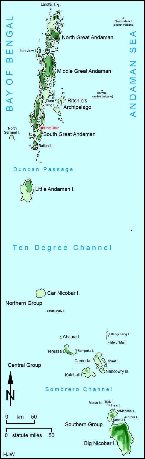
Despite their coral reefs, most Andamanese islands themselves are not of coral origin. Instead they are the peaks of a drowned mountain range. While there is only a narrow littoral, there are some shallow banks off the coasts of the Great Andamans, especially to the northwest and southeast. When the level of the sea was lower than today, these could have formed islands. North Sentinel island and Little Andaman are exceptional as they are relatively flat and mostly of coral origin. The other major islands are hilly with the archipelago's highest point at Saddle Peak on North Great Andaman. This hill, with its 738 m (2400 ft), might not look impressive but it has been called the most difficult mountain of his career by a famous Himalayan mountain climber and explorer. He found the slippery rocks, the thorny flora and the poisonous, clawed, biting and stinging fauna almost too much for him. The area around Saddle Peak was one of the few areas avoided by all the aboriginal tribes. They thought it haunted by evil spirits and dangerous animals. The first recorded ascent of the hill was claimed in 1882 by one Major Protheroe of the British army who showed a lamentable lack of sportsmanship: Indian convicts had to cut a path through the vegetation to the top before he and his fellow officers could made their ascent to claim a first.
|
|
Surface sea currents |
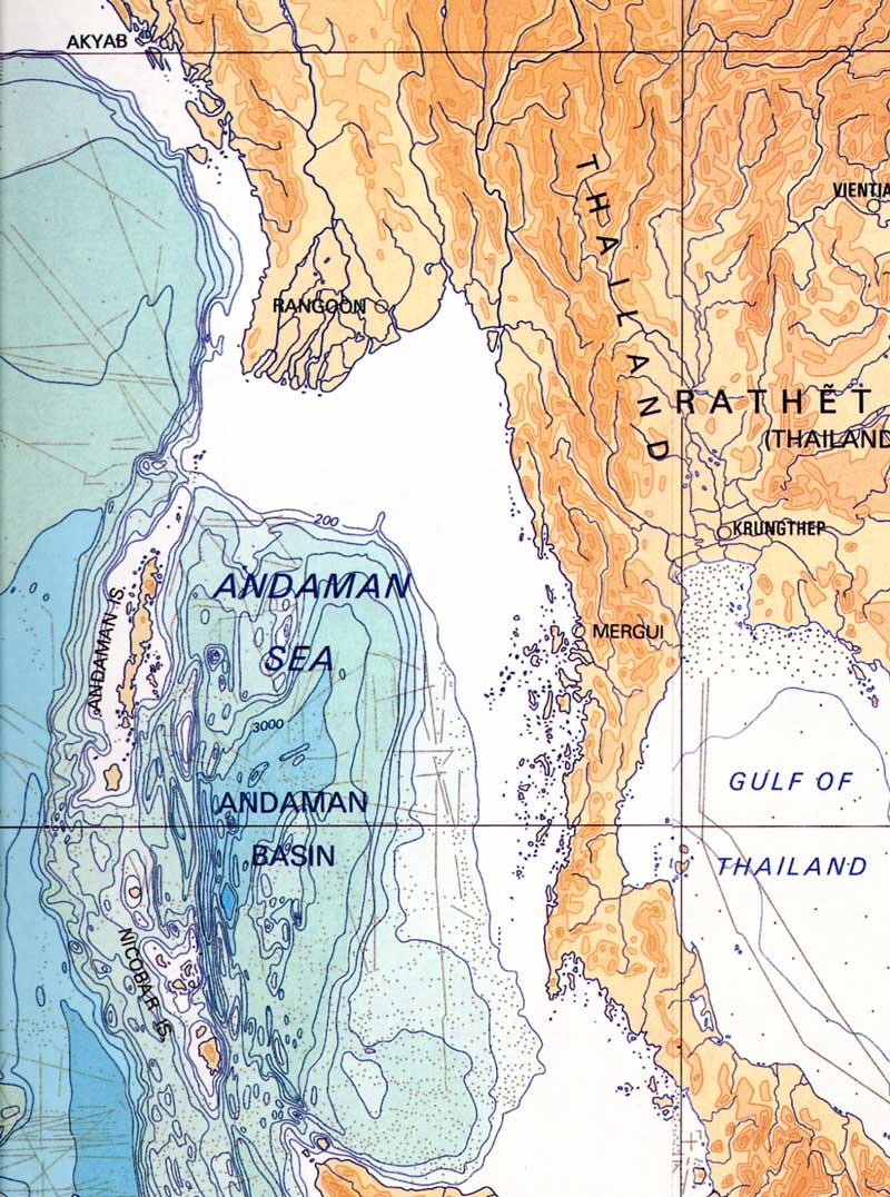
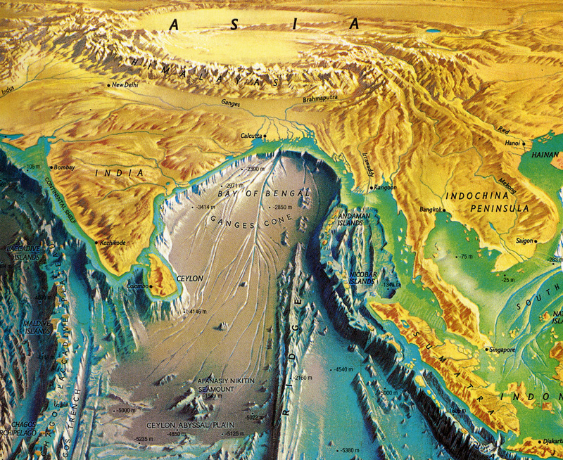
Different views of the Bay of Bengal and the Andaman sea (from M. Leier, World Atlas of the Ocean,s 2001, Firefly Books).
|
|
|
( Go to HOME )
|
Last changed 1 January 2009